This manual is for FoxtrotGPS (version 1.1.1+, 26 November 2012).
Copyright © 2012 the FoxtrotGPS project.
This work is licensed under....
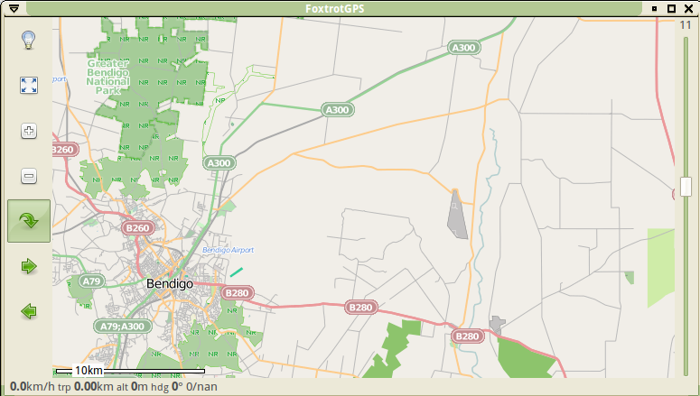
FoxtrotGPS is a GTK+ based mapping and GPS application. Its typically used to show a moving map showing your position in real time. It's useful as a navigation tool, for track logging (ie for OpenStreetMap) and trip planning tool.
By default, FoxtrotGPS uses maps from OpenStreetMap, but may use a range of other maps, some in experimental mode.
Clicking anywhere on the map pops up a menu of common operations, allowing such things as identifying the exact coordinates of that spot, distances to another spot, setting way points and downloading, in bulk, map data.
Click and drag the map to pan. As you do so, FoxtrotGPS will download the necessary map data and display it. That map data is cached (usually in ~/Maps) and reused when required.
There are also a number of keyboard shortcuts defined (see Keyboard Shortcuts).
FoxtrotGPS also has some features that require other software to be installed (see Geotagging Photos) and other features that can be enhanced be other software (see POI Icons).
Many devices already have a GPS built in but if your’s does not or you want to have it in a better position to "see the sky" then an external GPS is required. FoxtrotGPS uses gpsd to handle the varity of GPS hardware available, it's well documented and readily available wherever FoxtrotGPS is likely to be used. Actual GPS hardware options include:
A GPS Mouse might be a better solution in many cases. Reasonably cheap, powered from the laptop they have the advantage of being suitable to sit on the roof of your car making for better reception.
There are a number of keyboard shortcuts for common operations:
FoxtrotGPS can be used to geotag photographs that were taken while logging a GPS track, and can show icons on the map indicating where the photographs were taken; this is done by correlating timestamps in JPEG EXIF data with timestamps in the GPS track, and the following additional packages must also be installed for use at run-time in order to make use of this feature:
FoxtrotGPS can load distinct icons for different POIs from the directory ~/.foxtrotgps/poi-icons/; and, if you have the `mkvisualid' command from libvisualid installed, FoxtrotGPS can even generate distinctive icons automatically. For more on libvisualid, see its website.
FoxtrotGPS is quite smart when downloading maps. As you browse to an area or change zoom level if the appropriate map tiles are in the cache, they will be used. If not, FoxtrotGPS will attempt to download them, if it fails (because, for example, you are off line), it does so silently and tries to scale what ever tiles it does have, if any. This sometimes means blurry maps.
The solution is to download what you need before you go off line, just browsing is one way but that gets you only the current zoom level. Right clicking and selecting "Map Download" is often more useful.
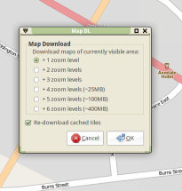
Its important to note that the download applies to the zoom level immediately below the one you are currently on, so go up a level before starting. Its sometimes useful to bring the window borders in a little to restrict the total download (and save some time and bandwidth), you don't have to download in full screen mode! Watch the little progress message bottom left, when it drops back to just speed and similar information, download is done.
For most people, the most useful maps in FoxtrotGPS are from Open Street Map (OSM). This is an open project to map the whole world and most of its content is contributed by people recording information and then contributing it to OSM. If you are using FoxtrotGPS in any sort of mobile mode, you are probably ready to do your bit for this worthwhile project. Please consider!
OSM needs all sorts of data added, we will look here at perhaps the mainstream activity, recording a road and adding it to OSM’s database. This process has a couple of clear steps:
The first step, recording, is where FoxtrotGPS come in. Releases of FoxtrotGPS after 1.1.1 have a useful icon on the main screen (left side) to start track logging, with older versions its necessary click the top left "Show Info" icon to display the Control Panel, possibly scroll it left or right until you see the Enable Track Logging tick box. In either case, start recording at the start of the road, stop at the end. Remember your GPS will be several metres out so accuracy greater than that is not essential.
FoxtrotGPS saves its logs in its own format but there is an excellent script included that will convert that log to an OSM format directly importable into (eg) JOSM. But before you convert, make things a bit easier for yourself and rename the road. Perhaps keep the date and use road name and condition. 20121107_Jones_Street_track_gr3.log.
The remaining stages are probably best documented on the OSM website, but do remember to mark your roads as "source=survey", the best source of OSM data.
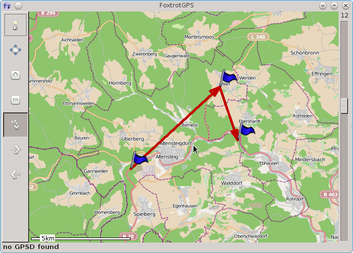
FoxtrotGPS allows you to plan a route in a few different ways. First, there is route finding, which finds a route from point A to point B. This is done by using an online web service, which knows how to get from A to B. Second, there is route planning, which allows you to plan a route through a number of points. This route is then transfered to a seperate navigation system (e.g. in a car) to guide you through the points.
Route finding extends FoxtrotGPS to be a simple navigation system. It takes two points and computes a route between the points. Here you see an example of such a route:
To use that feature, you have to click anywhere on the map and select the menu entry “route finding → get route”. It will open a small dialog allowing you to select both points:
Click on the "Pick" button right beside the text entries to select a point on the map. Alternatively you can enter the GPS coordinates into the text entries.
After clicking on "OK" you will see the resulting route on the map.
Note: You need an internet connection to access the web service, which computes the route.
Currently there is no turn by turn navigation telling you to go left or right, if you are approaching a crossing. You have to use a GPS device to show your location on the map and look at your current position to know where to go next.
Route planning is different to route finding because you will use FoxtrotGPS to plan a route and transfer that route to another system for navigation. This could be a navigation system installed in a car or on a motor bike. You do not need an internet connection for this kind of planning.
Note: If you download the appropriate tiles before your journey, then you are able to plan or change your route on the trip without any internet connection.
You use FoxtrotGPS to set a number of waypoints on the map. Together they form the route to travel, but without the exact route to follow. If you like to make a trip from point "A" over "B" and "C" to "D", then set these 4 waypoints. Here is an example:
Afterwards transfer these waypoints to your navigation system and ask it to compute a route through all these waypoints. Then you get turn by turn navigation from the navigation system, but you use FoxtrotGPS for easy and comfortable planning.
Waypoints can be saved in GPX or TomTom file format1 for use by a navigation system. Here is the above example as TomTom (ITN) file format:
     915240|4872867|WP1|0
     915438|4872786|WP2|0
     914980|4872469|WP3|0
     915309|4872313|WP4|0
     915693|4872355|WP5|0
To plan a route click on the map for the first waypoint and select “route-planning → add routepoint”. Then click on the next waypoint and select “route-planning → add routepoint” again. Repeat this for as many waypoints as you like.
At any time you can drag an existing waypoint to another location by clicking on it and holding the button down. Move it to another place and release the mouse button.
Clicking on an existing waypoint offers a menu to delete that waypoint or insert another waypoint before it.
The route can be saved by clicking anywhere on the map and selecting “route-planning → save route”.
Note: Do not set your waypoints on crossings. Instead, set them on the road between crossings. Why? If the GPS position of the crossing is not very accurate, then your waypoint is beside the real crossing. This will force your navigation system to make a turn to reach your waypoint and then asks you to turn-over.
Note: Humans normally choose cities as waypoints. E.g. travelling from Rome to Berlin normally goes over Munich. If you set a waypoint to the middle of Munich, then you force your route to go through the center of Munich, which is normally crowded and best avoided. A better strategy is to set the waypoints between the cities on a straight road without any crossings where you defintitevly must come through. This is also good for small villages, otherwise you will be sometimes directed to your waypoint, which is often not the best way to go through that village.
Note: Setting many waypoints forces the navigation system to stick closely to your route. However, if there is an "uninteresting" part on the route, then let the navigation system decide on its own by not setting any waypoints.
More information about FoxtrotGPS can be found online at its website.
FoxtrotGPS is a community developed fork from tangoGPS lead by Joshua Judson Rosen. tangoGPS was written by Marcus Bauer.